
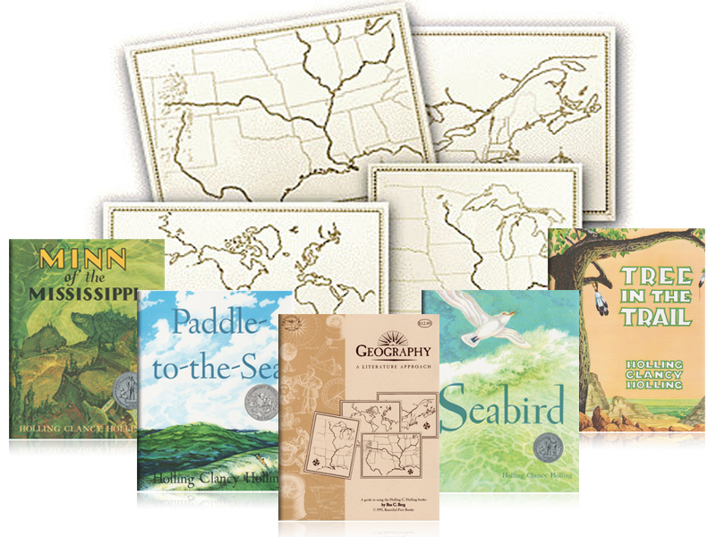
Today, I'm reposting a review written by Audria Story on her blog, At The Well. She wrote about our Geography, A Literature Approach program and I just had to share it here. She shares pictures of her children working diligently on the maps and talks all about how they worked through the program, what they chose to supplement, and much more. Enjoy!
Just before Christmas we wrapped up our Geography a Literature Approach guide from Beautiful Feet Books. The guide is built around four delightful Holling Clancy Holling books. Each book has an accompanying map to explore along with several suggestions (mostly books) for further expansion of studies. We’ve taken our time through this study, starting last summer during our break from regular academics. Once our regular coursework started back up we only worked on the maps and lessons once a week. The crew always looked forward to geography on Friday and were kinda sad when the study concluded. We (including me) love this study and I recommend hunting down as many of the extra books from the guide you can find. I will list our favorite books and resources below. I sorta wish I had bought myself a set of the maps to work on. Several times the kids shooed me away from their maps! The maps are really nice and high quality and stood up to my boys not so delicate treatment. We marked geographical features, colored in states, labeled capitals, and marked various routes from the books. The map work was my crew’s favorite part of the study.

geography lessons
The first book in the study we read was Paddle to the Sea by Holling. We truly enjoyed this book and marked the little boat’s route from Lake Nipigon above the Great Lakes to the Grand Banks off Newfoundland. From there the little carving is picked up by a sea-boat and taken to France. It is eventually returned to the Lake Nipigon area. We went down a few rabbit trails and learned about ponds, rivers, and the Great Lakes. Each did a one page report on the type of wildlife found along the area. They learned about the Canada Goose, copper and iron industry, canal locks, and how electricity is generated by Niagara Falls. I mostly did YouTube searches on these topics and several links are also provided in the guide. For our animal study I have some old encyclopedias the kids used and we read Pond and River, An Eyewitness Book by Steve Parker. Our favorite books were Champlain: A Life of Courage by William Jacobs and Cartier Sails the St. Lawrence by Esther Averill. These books follow the lives of two North American explorers. I know very little of Canadian history so I found these books just as interesting as the kids. Our favorite was the book about Jacques Cartier. We also read through chapter four in Susan Wise Bauer’s The Story of the World Volume Three.

homeschool mess
The second book is Tree in the Trail. This book is about a cottonwood tree growing along the Santa Fe Trail and eventually traveling the trail as an ox yoke. We traced the route of Francisco Coronado and learned more about the conquistadores inThe King’s Fifth by Scott O’Dell. The crew studied and wrote about cottonwood trees, buffalo, mountain men and the beaver trade, Plains Indians and the introduction of the horse to the American West. Our favorite book for this study, also by Scott O’Dell, was Sing Down the Moon. We all cried reading about the Navaho Trail of Tears. My crew took this book to heart and were upset to learn just how terribly the Native American people were treated. Some things in history are hard to teach especially the sins of one’s own country. During this time we started watching The West by Ken Burns. The program is about nine hours all together and we broke it up over a few weeks. We also made some Navajo frybread (can’t believe I forgot to take pictures!!!) and I told the kids stories about going to Pow-wows when I lived in Oklahoma. Some people like to put butter and honey on fry bread but I prefer mine with a bowl of buffalo chili.

Sparkles and her map from Tree in the Trail
The third book was Minn of the Mississippi. In this book we followed the life and explorations of an alligator snapping turtle from the origins of the Mississippi River to the Gulf of Mexico. For me this was the hardest book to read. I really struggled with some of the phonetically written accents. Also an immense amount of history is crammed into this little book so I just picked over some of the information. My crew wrote in their composition books about the life cycle of snapping turtles, explorers Jacques Marquette and Louis Joliet, North American Ice Age, river trade, the French fur trade, the Twin

page from Oldest’s note book
Cities, Mark Twain, steamboats, the New Madrid Earthquake of 1811-12 (we live near the fault area!), southern agriculture, the Siege of Vicksburg and the Civil War, and sea tides. We spent more time exploring some topics over others. Our favorite extra book in this part of the study was The Explorations of Pere Marquette by James Kjelgaard. My crew loved this book so much they would beg me to read “just one more chapter”. We read a few legends of Paul Bunyan and watched the Disney cartoon. We watched an episode of American Lives about Mark Twain and really enjoyed learning about life on the Mississippi from the famous author. Oldest requested some of Mr. Twain’s books to be added to his reading requirements after watching the program.

blacklight map
The final book was Seabird. My crew had a hard time deciding if this or Paddle to the Sea was their favorite book in the study. This part of the study is a basic overview of world geography. They learned about Eskimos, whaling (which really fascinated the boys), scrimshaw artwork, types of boats, and life at sea. I just want to share that you should not “google” for images of scrimshaw work with your kids in the room. Some of those sailors preferred…adult imagery! For this study Oldest got creative with his map. He used colored pencils that glow in a blacklight to mark the borders of countries (really vague borders at times) and to add in famous landmarks of some of the countries. He had a lot of fun researching his self-assigned project.


 My crew loved this gentle introduction to geography and I enjoyed teaching it to them and at times learning alongside them. I have even caught my hands-on, reluctant reader with the Hollings’ books a few times. The guide is recommended for grades three through seven. The introduction at the beginning of the guide gives clear recommendations and advice for implementation. I gave longer and more researched based assignments to my Oldest. My younger two gave many oral narrations and drew pictures about the topics we explored. Our favorite reference resources for drawing were several books by Edwin Tunis and Google images.
My kids always looked forward to geography time…and so did I.
Thank you Audria for giving us a peek into your family's experience of using the Geography, A Literature Approach program. If you're going to the GHC convention, you'll be able to meet Audria as she'll be helping us out at our booth! Be sure to pick her brain about using our programs!
This post originally appears at https://storyland4.wordpress.com/2015/01/20/geography-with-beautiful-feet-books/
We would love to hear what you think! Chime in below in the comments section and share your thoughts. Don't forget to check out our Facebook and Pinterest pages. To learn more about Beautiful Feet Books, click here. And if you've enjoyed this, please feel free to share using the buttons below!
We would love to hear what you think! Chime in below in the comments section and share your thoughts. Don't forget to check out our Facebook and Pinterest pages. To learn more about Beautiful Feet Books, click here. And if you've enjoyed this, please feel free to share using the buttons below!
No comments:
Post a Comment